I want to know how to create realistic mountain ranges. In real life they tend to branch out, and the erosion paths are very deep. I can’t seem to emulate that effect in world machine. Its the effect of a ridge with smaller ridges branching out of it.
These are actually really hard or impossible to achieve in World Machine procedurally since those mountains follow a very accurate and realistic big scale hydrological river system.
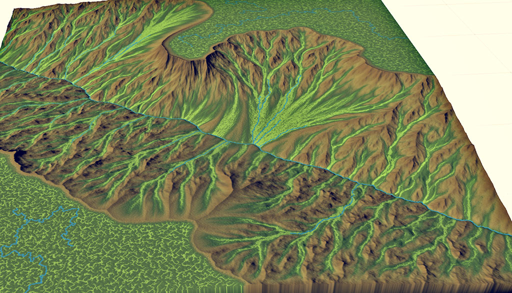
World Machine right now actually works better for up close mountains like this rudimentary scene I made as an example:

To demonstrate what makes it impossible to create such shapes as of right now this is what the scene I made looks like at a distance

As you can see it follows no realistic structure.
The most feasible solution to this would be to write your own device with the SDK to generate fractals, which actually resemble the branching structure of real world river systems.
But if you are patient enough there seems to be another solution on the far horizon: on one of the latest blog posts Stephen secretly shared images of a new river/erosion system he has been working on (i presume), here is an image he teased us with:
With this new system you probably would be able to recreate something that resembles the screenshot you sent.
Last but not least I recommend you to use real world data, like SRTM, which can be easily downloaded from here https://terrain.party/
Super thanks for terrain.party link. I realy appreciate it.
The amount of real world terrain data out there is huge, another great resource is https://earthexplorer.usgs.gov/ and http://www.opentopography.org/ although those are much more advanced and require a bit of knowledge or fiddling around to import into World Machine
What about other planet? Mars, Venus etc
Actually for mars there is a very big dataset with hand picked individual pieces downloadable here http://www.uahirise.org/dtm/ some of them look really interesting.
For venus I’m not sure but a quick google search reveals that there is data available to the public
Thank you for the help!
Aside from the mountain range level generation, how does one make the smaller scale stuff? with the same principal of branching ridges?
No, for smaller scale environments just use Advanced Perlins and voronoises as a base, or layout generators if you want to have more control over the shape.
If you are only doing a single mountain keeping it accurate on a hydrological level doesn’t really matter
example height map of what I mean:
That example has a bit too much branching going on, but something similar can be achieved by heavily eroding a terrain, to the point where it’s almost flat, then clamping it to make it steep again, use that as a base mesh for further modifications
Under heavy erosion there are a lot of unrealistic axis aligned artifacts, there are too many straight erosion paths. How do I distort these? the erosion paths in the example height map were all bent in some way.
There is no real solution, just make sure you don’t have inverse filter enabled and try to distort the whole terrain afterwards