It would be great if the Mesh Output could export more elaborate meshes. Instead of blindly exporting a face for each pixel, it would be great if it were possible to have a “feature detail” control that will, instead of just outputting a low resolution mesh, output an optimised mesh that retains the terrain’s features, as illustrated below, where you can see a low poly terrain with still an absurd number of faces and blurry shapes versus a heavily reduced low poly sketch on top of the high poly terrain.
Minimal Slope Delta
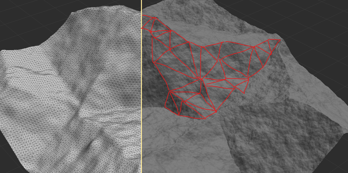
I think this is best implemented as a “minimal slope delta” parameter, which determines the minimal difference in slope between 3 (or more) vertexes to remain 3 (or more) separate vertexes instead of being blended together. This ensures that, when for example a hill has a 10*10 pixel area with an overall slope of 1°, WM will no longer export every single vertex in between, but only the start and end vertexes of that area, resulting in a reduction of 96 vertexes (see the image below for an illustration).

- This prevents creating unnecessary detail (as seen in the low poly mesh in the first image), as an area with a constant slope will now result in just one big face with 4 vertexes instead of a subdivided plane with maybe 4096×4096 vertexes (if you were to export a Constant device’s terrain at 4K res), which is a waste of resources.
- Since a low slope delta is almost analogues to a low feature area, it is a logical parameter to add.
- It is an easy to understand parameter, as slope is a commonly used tool in WM.
- “Downscaling” a high resolution image to a low poly mesh will probably look better than a mesh of a low resolution image.
Reasoning
As of now, it is not really possible to export a low poly terrain without losing shape determining features, such as ridges. Instead, the overall quality is reduced and still a lot of “unnecessary” detail remains, so you end up with a blurry terrain with still a lot of polygons. Also, a high poly mesh is difficult to handle/edit, often results in stuttering in the 3D program and has an immense file size, and therefore is annoying to work with.
WM already provides a normal map maker and to combine that with the low poly mesh creates for convincing terrain without all the extra polygons and since, when creating a detailed terrain, you’re most likely going to use ground assets, the low poly terrain will be hidden from sight.
Downsides
- This will probably no longer support quad faces as I think it only works (or works best) with triangles.
Current work arounds
- None that I’m aware off, except for using a 3rd party application (in which you will have to work with a high poly mesh which is often a nightmare).
 There’s a small set of mesh-related features that I might try to do a release for in the next year - for example, I have a proof of concept for a mesh -> heightfield -> mesh workflow that is pretty neat, as you can basically apply WM algorithms to your already irregularily triangulated mesh.