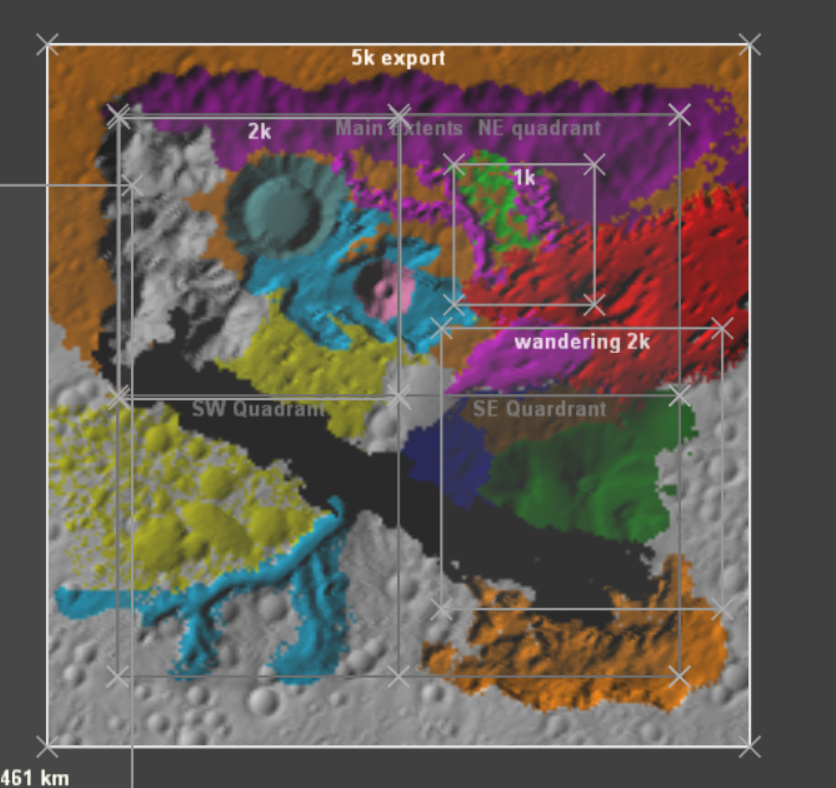
So we have local space and tiled builds, would it be possible to have minded render extents for a world. What I mean by this is that while the main global extents would be for example 80km by 80km with 8k by 8k resolution, there would be one area where World Machine was sticky working in 1km by 1km with 1k by 1k resolution that would then merge with the main node setup. This would be useful on maps like this
This is a 250km2 with 5k by 5k resoltuion map Ive been working on recently and as you can see is ridiculously complex. I paged about 50GB of data on just the terrain stripped down to a collection of file inputs and an additional 250GB just for the coloring. Additionally, I had to macro some of the terrain sections to save ram.
Now, most if not all of these features would have fit in a 20km by 20km extent, in fact, later on, I would render the separate terrain features individually and import them as file inputs.

The issue with that method is that now the flow has been broken and if I do want to make a change on one of the areas I would have to rebuild and export with the same render extents.
It would be ideal if World machine could render those areas at just 20 by 20km with the performance and ram advantages at working at such scale. It would also fix some scale/resolution dependence issues World Machine sometimes gets when switching between two different sizes render extents. The custom render extents would work the same way as local and world space do now, with setting devices to use a custom extent via groups. The yellow lines are route pickers that enable/disable nodes on the terrain depending if they are in view or not, something like that would work for the custom render extents as well, where the set of nodes is just completely bypassed if the custom render extent does not fall inside the main one.
Now, this would obviously be complicated to implement, how would those render extents work when it partly overlaps the main extents, what to do at the borders of the smaller render extents, how to discard data, how to implement it with the tiled output.
I would love to hear your thoughts on this.