Water Mask and Water Output Macros provide masks and geometry of water, but is there a way to export the water height as a heightmap?
I see someone asked a similar question but got no response: ‘Export Scene View’s water heightfield?’
Hi there,
Yes, absolutely! Very helpful question to ask that I know other people have wondered as well. Add a composite device to unpack the water datatype into its components:
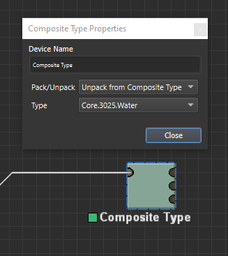
You’ll see that the water type is made up of the water elevation top surface, its depth at that point, and a flowmap (which is another composite type). The elevation and mask are heightfields and can be exported or manipulated as needed after unpacking.
Thank you for pointing me to this node, was able to get what I wanted using the depth mask to isolate the water heightfield.
1 Like