I’m training to be a world builder with the use of Adobe Illustrator or Photoshop and World Machine to import into Unreal engine 4.
I’ve tried this on my own and at this point I am stuck due to not understanding how something like this can work.
The idea is to create a flat map in Adobe Illustrator or Photoshop with the sections all worked out from a flat image. Import this image into WM, turn on transparency mode to see through the image as I do my elevations per sections.
Maybe height maps is the way to go with this. However to go that route it may take some clever editing sections of maps until I get something close. But I thought to come here and ask are there any videos out there on this topic at all. Or do you have others out there that’s tried this and have success at it.
I’m almost at the point of not trying this due to time wasted on my own while getting my head around WM. I’m hoping there is a way and coming here to request tutorials or even features inside of WM that someone like myself can learn and move forward.
The second thing is the coloring phase of land mass. I see in your videos you have colored areas on the examples. I’m curious about once this gets imported into Unreal will the colors transfer as well or will they import in dull and not so well planned out and I’d have to go in to Unreal and recolor everything?
If anyone is reading this that can help point me in the right direction, Thank You. However this is something I wanted to ask the creators of WM for help and if there are already features in WM that can do what I am trying to do but maybe I am going about this the wrong way on my own.
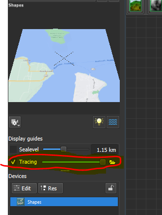
If you have an actual elevation heightfield, you can of course import it, but if you just want to recreate an external map inside of WM, this exactly what the new “Tracing” guide in Mt Rainier is for!
Here’s a quick workflow:
Click the ‘Tracing’ guide on, and use the folder icon to open your flat image. Here I’m using a quick clipped-from-google-maps image as an example:
The slider controls the opacity of the tracing aid. It will appear atop all of your terrain in World Machine; you can toggle on or off with the checkbox.
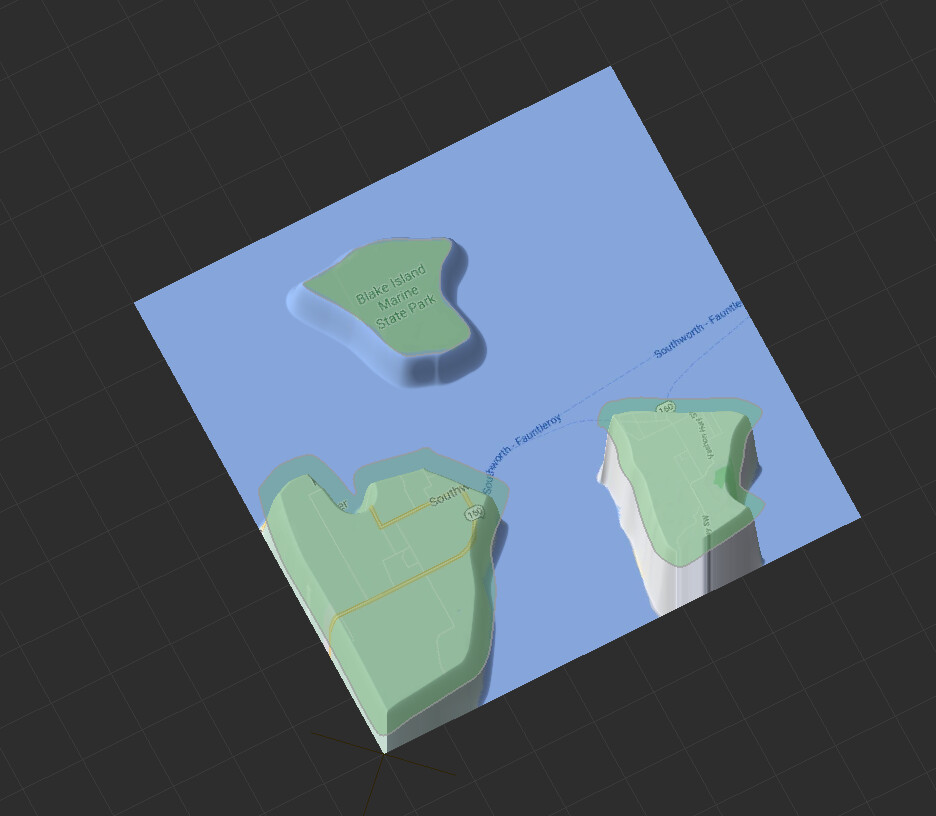
Create a "Shapes’ device in World Machine and double click to go into the visual editor. Now create polygon/path/etc shapes according to your tracing guide:
Adjusting the opacity or rotating the view as needed to see what you are doing. When you’re done tracing, you have recreated your image file as a set of vector shapes in WM:
Addressing your last question, texturing is a different problem but you can export a texture map to be used inside of UE as a material. Perhaps someone else can give you a good workflow for that!
Thanks for this tip. It’s at least something to try and see how far I can get with this method. As for the lifted areas. I am wondering if somehow each section can be masked off some how to use the features in WM to vary each section to give is character.
Not all sections will have the same height and depth.
For drawing out maps in illustrator specifically, once my mouth fully recovers from getting these wisdom teeth pulled, I’m planning on doing a full tutorial series on my workflow for doing just that. The tutorial series will mostly be focused on using the workflow to create 2D maps for things like TTRPGs and the like, but to generate heightmaps for a game engine is going to be the same process, just ended a bit earlier.
It’s been awhile since I’ve been here or used World Machine (the pandemic hit right as my computer finally kicked the bucket, so I’ve been without one for almost a year now), so I’m gonna take some time and familiarize myself with the newest version, but hopefully by the end of next week I should have some solid info for you!
For an example on the kind of thing the workflow I’ll be showing can do, I have an older post in the Works In Progress topic titled “Campaign Map (2D Map from WM Test)” where I used the workflow to translate a hand drawn pen-and-paper map into a World Machine terrain.
Greetings Blattacker - We;come to the subject and I would greatly appreciate your input on this.
Let me know when your tutorial is ready for purchase and I will be one of your customers for sure.
If you read above. My thoughts are to create blueprints of a large world/level flat with key sections on it and bring into WM and style it from there. The thing is. Are there ways to isolate sections and use the features in the masked out sections and raise the height lower things. meaning slowly model the map sections as if we are sculpting it section per masked section until the entire land mass is done following the sketch from Adobe Illustrator or Photoshop. Not sure yet, maybe a combination of the two.
I’ve looked around to see if you can mask specific areas and work on them one at a time on a land mass. Maybe this is possible but not seen anything like it here.
I will toy around myself with what you guys suggest. When it’s all said and done I will share my progress on here and maybe someone else will find this method useful now or later.
I also found the post you mentioned. I wonder if like you said "Planning Out Multiple ((Biomes)) To keep the landscape varied and interesting. So I guess the feature ((Biomes)) is a major key to masking or do I have this wrong?
I also reviewed this " Worldbuilding: How To Design Realistic Climates 1" by Artifexian , interesting tips.
No worries about purchasing anything, the tutorial is just gonna be a series of free YouTube videos. I hesitate to tell you the workflow now, as I’m not sure if anything has changed with the LTE version of World Machine, but I can tell you’re a bit anxious to get started, so I’ll give you a basic rundown real quick.
Essentially what I’d been doing is creating shapes on individual layers in illustrator. The first shape is just the general outline of the landmass, then on top of that, drawing basic mask shapes for things like mountain ranges, valleys, lakes, etc. I would then save each individual layer as it’s own svg (after running the “simplify” command in illustrator, and selecting the “convert to straight lines” option). From there, I would import each svg file into it’s own layout generator, and use those as either masks for generator nodes, or shapeguides, or combine them all to use as the source for a chooser node. That part is completely up to personal preference.
As for the biome part, that is more for the texturing process, and was more of just speaking on how difficult I was finding blending between, for example, desert and forest areas in a natural way.