Need help with ongoing project

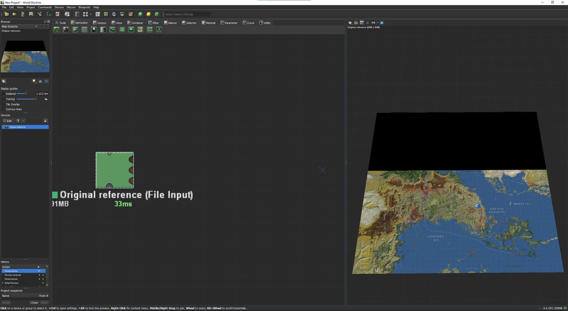
For starters I am the absolute worst in the world in learning new things. I tried learning WM in 2017 or so and it was a disaster. Nicest guy from this community (no idea who…) tried giving me lessons and I have long since known I am dumber than a rock. The whole endeavour didn’t click for me. I just had no idea how to make the WM interface do stuff for me. I might have angrily destroyed furniture and I gave up.

I have since then no doubtr grown even dumber. I think it’s a bad case of ADHD, and I am not getting any younger. My world building is more a linguistic, discriptive, storytelling thing.

Showing me your “howto” youtube video would as pointless as trying to educate your grandmother how to program in INTERCAL.

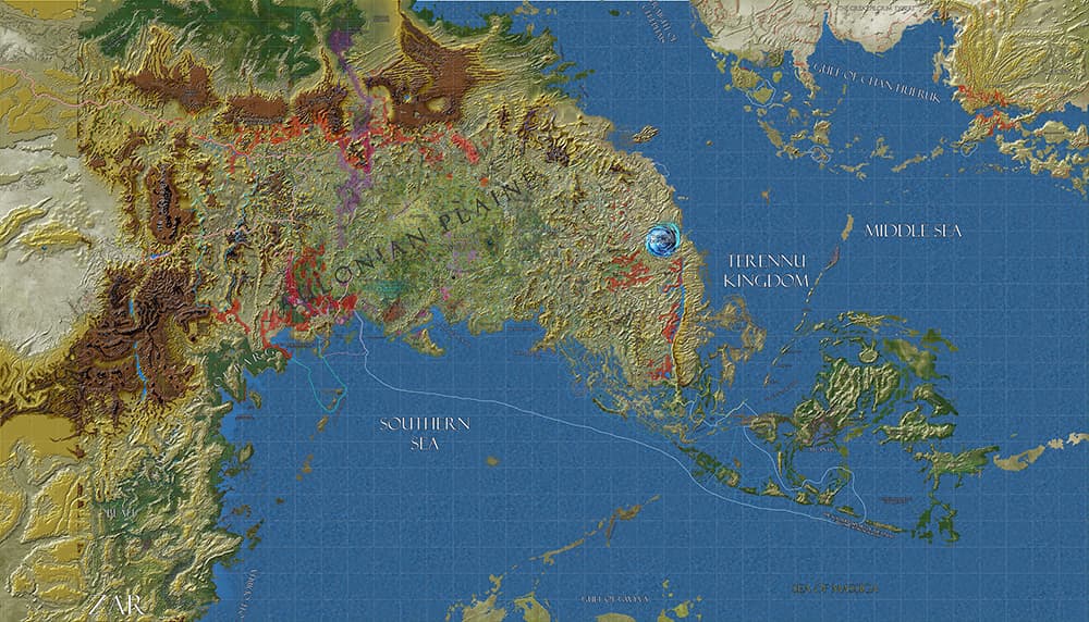
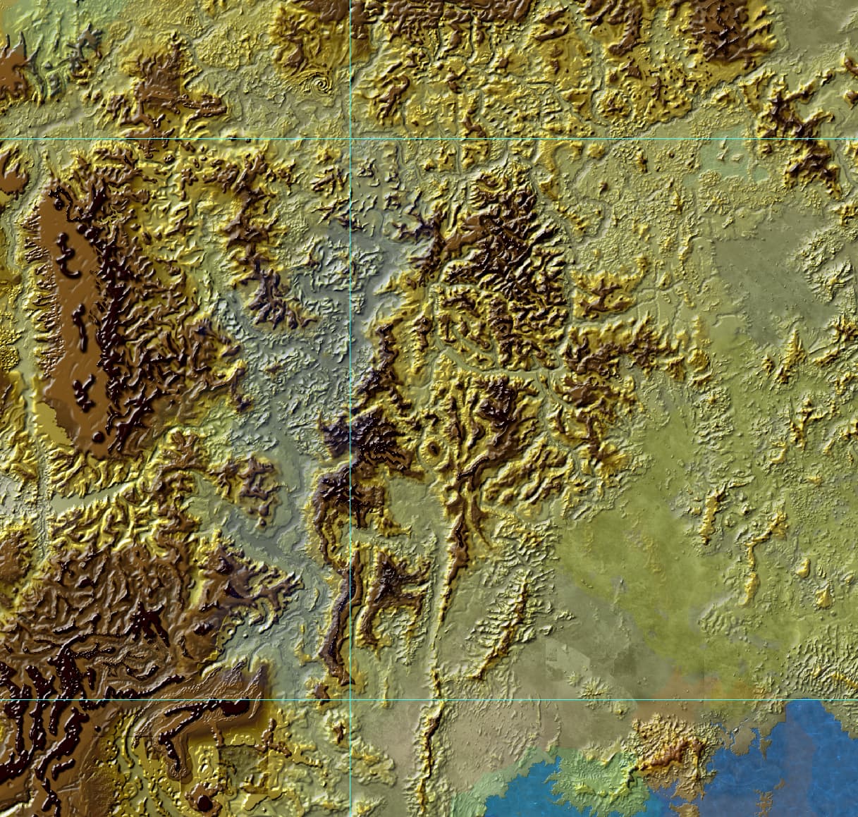
However over the span over 25+ years I made a huge landscape map in photoshop - handpainted with greyscale maps (full neaderthal mode), in consequtive height ranges, as to somehow bruteforce mjolnir photoshop into depicting several overlapping height ranges. A geologist looking at this would scratch his or her head no doubt and say out loud “this map is total nonsense”.

The current map I am working on is (…) at 300 DPI a full 2 by 4 meters, of which I am most interest in the central half, let’s say one by two meters. That’s tens of thousands of pixels, at a scale where one pixel is 100 meters.

In a more perfect, magical, awesome world I would somehow magically find a generous, kind, sharing soul that would help me make this current “smashed together” height map, take various sections of the map, isolate them out and turn them into discrete and consistent geological regions, subject them to the various mystical swish flick (and for me completely incomprehensible) algorithms and somehow still a geographically a lot more plausible collection of river flows, sedimentation, erosion, etc. etc. and then make a SINGLE height map from that, which I can then reintroduce back into my photoshop map.

I have no idea how complex all this is.

If you tell me “this is an afternoon’s work” I’d believe you and start dancing in pure joy. If you’d say in a somewhat hoarse voice “this is a project for 20 people lasting a year” I might also nod sadly, dejected and quietly retreat, avoiding eye contact and never bother the WM community ever again. I’d get over it, but I’d be sad for a while. I’d most likely neve try again.

Now let’s assume it leans towards the the first - all these grandiose and lofty ambitions is doable, and it fits in the constraints where some mother theresia kind of geneous soul would come forth and say "this sounds like a LOT of fun to do", by all means, let’s proceed to discuss details on cam.

1 Like

@Khannea I gave a like because I smiled all through your post lol!

Bad news: Its never an “easy” job building a 3D terrain realistically, based on someone else’s work. That said, I do it for a living, so it CAN be done. Any prospective person would have to be very skilled, and would need a lot more detail about the requirements before they can even attempt such a meticulous project of potentially massive scale. I personally am not free right now, but I can see the reference, and it can be done given enough time, energy, and skill.

Good news: The thing you’re dreading (learning a new tool, aka World Machine), is actually not that hard. You just have to be open to the experience. It’s certainly different from your current skillset, but if you figured out Photoshop, you can figure out world machine. IMO it has a much easier learning curve compared to Photoshop. Also, forum member @Ben attempted something of this scale back in 2013
So it definitely CAN be done!

1 Like

@Khannea BTW half of the work is already done, now you just need to export your layers in a good quality raster format, with at least 16 bits per pixel color depth. Then you can import those into world machine directly.

1 Like

should export a high resolution B&W height map?

I meant import your Map image, in full color, right into WM. To be used as a reference. Heightmap would need to be build manually by hand, it won’t be as easy as converting color to grayscale.

Four of the Layers in the Photoshop file ARE overlapping greyscale maps, with a layer effect that emulates height levels.

Also bear in mind the landscape I work with is (NW to SE) the distance from Iceland to Azerbaijan. It’s huge.

Also also bear in mind that a lot of the local feudal domains are formed largely because of rather subtle elevation shapes. I can’t simply repaint tens of thousands by ten thousands pixels worth of content that’s already completely embedded in 30+ years of world building canon.

The goal is to take whatever elevation patterns I have right now, grab sections where I can conclude they have certain geological (weather, geology, sedimentary deposits, magical effects, mining, megascale landscaping, etc. etc.) predispositions and change these from more or less scientific/less plausible blobs into the absolutely breathtakingly beautiful (and deeply convincing) surfaces generated by world machine. A major part is of course that the river flows have already been selected.

1 Like

Concluding - maybe it is simpler if someone says to me “Take it elsewhere, WM is a completely unsuitable for your stupid project, and/or this software is way way way to complex for what you are trying to do versus someone with your abilities”.

Then again, maybe someone says something completely different.

@Khannea It’s a massive project, and even from a very limited perspective its nowhere close to stupid. Of course all of it would have been easier, and less time consuming if it was built from the ground up in WM. That doesn’t mean it can’t still be wrangled. If I had some time, I’d volunteer just for the challenge, but there has been a death in the family, a boy of 24. Things are tight and tense over here. To top it off anything too big (continental scales), or incredibly small (1cm/pixel or smaller scale of detail level), is very hard to do algorithmically.

If you have layers layed out like that, then export each individual layer as a 16bit TIFF, or EXR. You can import both Grayscale and RGB Color images into World Machine, then you can go from there. If you can send me the indvidual layers in above detail, I can at least set up a starting project with all your data loaded into World Machine. Then you can take it forward from there, WM artists appreciate some head start.

That sounds great. Do bear in mind I started painting sections of landscape on photoshop in the late 1990s.

I will try isolate a small section, amputate a blotch of elevated region. How many pixels (at 100 meter scale per pixel) is optimal to work with?

I can work with 8192x8192 Pixels for a single monolithic terrain, or color image.

At continental scales, that’s nothing at all. That’s why people do this sort of work in “tiles”. That’s why I said that thing about too big or too small terrains.

8192x8192 would signify a huge section of the central western Kingdom and adjecent Queendom Raell.

Isolating out the map data not relevant to this landcape rendering, this is the resulting landscape, with rivers …

and without rivers/vegetation

As you can see this is largely unpainted rough in large sections to the west. However I would implement the magic of world machine specifically to the largely painted and defined “Bhutakh” section in the middle.

Elevation levels I have defined as 1000-2000 (yellowy), 2000-3000 (mustardy), 3000-5000 (reddish brown) and 5000-7500 (dark brown) BUT there are assorted peaks over that that stick out higher, some higher than 10 kilometers. Each elevation layer overlaps the lower one, and thus my first question would be - can you meaningfully overlap/unify these map layers in WM, or should I follow some kind of overlap/additive to make it into one height map. I can do it according to your specifications but if you want to process into some specific way I can deliver them to you as is.

I would cut out large sections of mountains to grab a specific geographical section in the middle. I want to keep the load on you as minimal as possible to benefit from your generosity. Also if you can’t realistically do this because of personal circumstances, it’ll come in a few months.

1 Like

TBH send me the layers for parts you “plan to edit in world machine”. I’ll load those into world machine, set up a starting project and folder structure for you. I’ll label things using groups, so that you know what’s what.

I’m also going to need the “version” of world machine you’re on. The file needs to be compatible to your specific version of WM. If you’re using the latest stable build, ignore this bit as I have that one already installed.

The version I hae currently installed is Build 4031.2
That’s a free version, it’ll take a month or two before I’ll be able to afford a Real People ™ version. This one will probably be throttled in all kinds of ways. I clicked buttons for an afternoon, with absolutely zero result. I have no clue how it works, probably won’t even have after months of clicking buttons and yelling at it.

:rofl: :rofl: :rofl:

Yeah you have the latest stable version, my projects SHOULD work on your end, though resolution will be limited to 1024 pixels.

There’s a method to this madness, and this time you can ask the community “specific” questions when asking for help. I have a “basic tutorial” sort of project on this forum somewhere, though it doesn’t cover absolute basics like “what buttons to push”, more of a general overview of “procedural terrain modelling”. You can find it Below. Download the last version, and extract to a convenient location you can read and write to. Folder structure is already created, everything is contained within the extracted folder.
And about the problems you encounter after starting world machine, ask here on the forums. No question is too basic, we’re all here to learn anyway.

P.S; This is the tutorial iteration you need if you want to learn the basics, fixed some typos from earlier versions. Tutorial Project: Basics of procedural terrain modelling in World Machine - #4 by WFab

Oh I missed the part about your elevation layers completely! Sleep deprivation lol!

So FYI I’m colorblind, so you’ll have to unify those elevation layers yourself, preferably using a grayscale gradient. You can import RGB images directly into wm, and do it there. Or you can use photoshop (whatever’s convenient). Of course the data is interchangeable, but as I said I have problems interpreting colors myself.

About specifics, the HEIGHT data should be 0-1 grayscale, saved in a format that supports 16bit float values minimum (EXR 32bit works too). RGB should work as is, I’ll have to see what I can pull into WM on arrival.

P.S; Forgive the edits, it’s been a long night…

This topic was automatically closed 90 days after the last reply. New replies are no longer allowed.