That is, sadly, the expected effect.
The Coast Erosion device will create a water body based on the terrain it gets fed from the Erosion device. It changes this to create some beaches and then you have your output with a water body “linked to it”. However, when you add a River Device, it will affect the terrain, and also the terrain at the beaches sadly, destroying that “link” between the Coast Erosion’s water body and the (now changed) terrain.
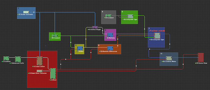
But probably more important to you is how to fix this. This is some more advanced World Machine stuff, so don’t panic if this all seems like “weird magic stuff” to you and just follow the steps and look at the image below for reference. Note, not all steps (2, 4, 10 and 12) have a corresponding coloured box in the image.
- We are going to add a
Scalar Generatorto the world. This device will determine the sea level for ourCoast Erosiondevice and two other devices. Now we will also add aConstant Deviceand aSelect Heightdevice (note, we are using the old version of theSelect Heightdevice, to change the version, right click on it, go toChoose device versionand select theLegacyoption).
You must link theScalar Generatorto theSea Levelparameter of theCoast Erosiondevice, theHeightparameter of theConstant Deviceand theMaximumparameter of theSelect Heightdevice. - We will be adding 3
Combinerdevices. - The first
Combinerwill be set toMax, with itsStrengthset to 1, and we will link it to theConstantdevice and the terrain output of theRiverdevice. - We will now link the
Select Heightdevice to the output of theCombiner[Max]from step 3. - The second
Combinerwill be set toMultiply, with itsStrengthset to 1, and we will link it to theSelect HeightandConstantdevice. - The third
Combinerwill be set toAbsolute Differences, with itsStrengthset to 1, and we will link it to theCombiner[Max]output from step 3 and the terrain output of theRiverdevice. - We will add a new device, the
Composite Typedevice. Open its properties and set thePack/Unpackparameter toPack to Composite Type, and theTypetoCore.3025.Water. The device will now have three inputs and one output. To the first input,watersurfacewe will link the output of theCombiner[Multiply]from step 5. To the second input,depthwe will link the output of theCombiner[Absolute Differences]from step 6. - We add another
Constantdevice, and set its height to half the world’s height. So, if your world’s max height is 1500 m, you set theHeightparameter to 750 m. - We add another
Composite Typedevice, and set its parameters toPack to Composite TypeandCore.Vectorfield. We now link theConstantdevice from step 8 to both inputs. - Link the
Composite Type[Core.Vectorfield]to theflowdirinput of theComposite Type[Core.3025.Water]device. - Now combine the two water bodies with the
Combine Watermacro, just like you did before. - Hook up the terrain of the
Riverdevice and the water of theCombine Watermacro to theScene Viewdevice.
What this scheme does is creating a new sea with the Constant device, does a bit of clever Combiner stuff to get the appropriate height maps, then creates a new Water System with the Composite Type device, which we now can combine with the river. Since this operation is done after the River device, the sea will be different from the original sea we got from the Coastal Erosion device, because the terrain has been altered by the River device. I hope this helps, let me know if you have any more questions.
And the .tmd file (118.5 KB), in case you want to download this example.
