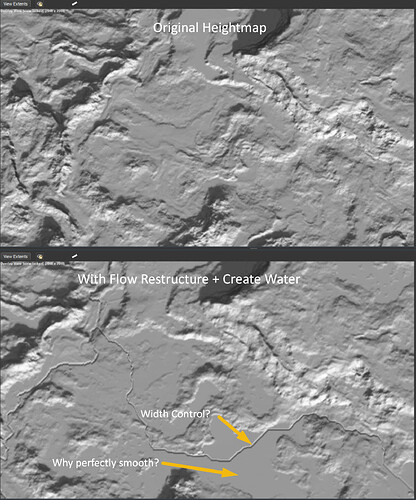
I haven’t worked with Flow Restructure + Create Water before and I have some questions about my current results.
Firstly, am I seeing these glassy smooth areas because the overall lay of the land is quite flat, and water has collected, or…? How should I avoid them?
Secondly, is there any river width control available using these nodes, or are you confined to relatively thin, uniform river shapes?
The Flow Restructure device will “fill up” your terrain if necessary to ensure water can flow out of your map. These smooth areas are places where it is filling up the land. I think it is best practice to avoid them, which you can do by allowing Flow Restructure to carve more aggressively into your terrain by setting the Ridge Carving parameter to 1. However, even with that setting, it can still occur. Another good practice is to already make your terrain more “downhill” and prevent deep crevices. Running an aggressive erosion pass just before the flow restructure can also help.
There is, you can use the Discharge Scalar parameter for that. At their origin, rivers will always be small, and they will increase in width the further away from their origin they are. With the Discharge Scalar parameter, you can control how quickly that happens.
Discharge Scalar! A whole new world. Excellent, thanks for the tips!
